Can a Super El Nino save Colorado from deepening drought conditions?
Not even a Super El Nino — which climatologists say is likely to develop this summer — could undo the damage in Colorado after a historically low snowpack. It may, however, offer a glimmer of hope that relief is on its way.
“Overall, between the very low snowpack and the warm, dry winter and start to spring …. we are in drought conditions across basically the entire state, and they, at this time, are worsening,” said Peter Goble, the assistant state climatologist at the Colorado Climate Center, said at the monthly Colorado Water Conditions Monitoring Committee meeting on Tuesday, April 21. “But this is probably the most optimistic seasonal outlook that I’ve been able to give on one of these calls in quite some time.”
El Nino and its inverse La Nina are two phases of a climate cycle related to abnormal changes in ocean temperature. When temperatures in the tropical Pacific Ocean are warmer than average, it results in El Nino conditions. When temperatures are cooler than average, La Nina is the result. The ocean temperatures can drive different weather patterns across the world. Historically, El Nino conditions bring wetter summers and falls but drier than normal winters in the Northern Rockies.
However, Goble likens the weather predictions associated with La Nina and El Nino to a game of poker.
“It’s like playing poker with a few extra Aces and Kings in the deck,” he said. “The odds may be stacked in your favor, but you could still draw a crummy hand.”
The 2025-26 winter offers the perfect example. Typically, in La Nina winters, the Northern Rocky Mountains tend to see above-normal precipitation.
“We had a weak La Nina over the last winter, and it was obviously much drier than normal, for many record dry,” Goble said.
A graphic from the Colorado Climate Center illustrating the historic impacts of La Nina and El Nino conditions on state precipitation in each season, starting with December, January and February in the top left. Areas shaded blue tend to receive more precipitation in La Nina years, red in El Nino years. Colorado Climate Center/Courtesy Photo
Now, the cooler ocean temperatures that brought La Nina this winter are officially gone.
“Just off the coast of South America, you can see warmer than normal sea surface temperatures developing there,” Goble said. “It’s likely that this is going to grow into an El Nino event, and it might be a big one.”
This summer, sea temperatures are projected to be 2 degrees Celsius above normal — the threshold for climatologists to crown it a “Super El Nino.”
Goble said that while there is “nothing magical about the 2 degrees Celsius threshold, where if we tip into super, it’s going to suddenly do something amazing,” there are some indications that “the stronger the El Nino, the higher precipitation may be.”
“The more pronounced the pattern, the closer we can be to being confident in some of these effects on precipitation,” he added.
According to Goble, there are three Super El Ninos on record in Colorado. This includes 1983 and 1998, which were “very good snow years” and 2016, which was an “average snow year,” he said.
“Overall, I don’t think we’re looking out quite that far yet,” Goble added. “For this summer, it does help our odds of a wetter than normal summer.”
The April 20, 2026 International Research Institute for Climate and Society model shows a high probability of El Nino conditions developing this spring and continuing through the end of 2026International Research Institute for Climate and Society/Courtesy Photo
While the latest National Weather Service forecasts show an increased probability of above-normal temperatures in Colorado from July to September, precipitation outlooks are creeping back toward normal or slightly above normal for the summer months.
This move to El Niño coincides with forecasts showing a strong possibility that Colorado will see an active monsoon season, according to Goble.
The North American Monsoon is driven by a shift in wind patterns that brings continuous moisture from the Gulf of California to the southwestern United States, including Colorado. It typically kicks off in July and extends through August, and can bring consistent afternoon rain and thunderstorms.
However, these more “optimistic” long-term outlooks come as 98% of Colorado is experiencing some kind of drought. Over half of the state (54%) is experiencing severe to exceptional drought conditions, according to the latest U.S. Drought Monitor. Conditions are the worst in northwest Colorado.
“This is an area where not only has winter snowpack been at record lows, but last summer was also critically warm and dry,” Goble said.
Nearly all of Colorado is experiencing drought as of mid April 2026, with the worst conditions persisting in northwest Colorado. U.S. Drought Monitor/Courtesy Photo
While April brought some “decent moisture” to the Western Slope, Goble said it did little to “change the big picture narrative of the winter season in western Colorado.”
Whatever moisture comes this spring and summer, however, is unlikely to reverse the impacts of this winter’s historically low snowpack and record hot temperatures.
“When it comes to our water supply, I think that the damage is already done,” Goble said. “A wet summer would be much better for our water supplies than a dry one — (it) reduces irrigation demand, helps with fire suppression (and) potential marginal boosts to storage. However, we don’t capture nearly as high a fraction of our summer moisture in our lakes, streams and reservoirs as we do our winter moisture.”
Regaining the losses incurred at Colorado’s large reservoirs like Lake Dillon, Blue Mesa Reservoir and Lake Granby is “highly unlikely” this summer, Goble said, adding that it “would take disastrous flooding to do so.”
Still, if forecasts hold and Colorado sees above normal precipitation this summer, “we would certainly take it,” he added.
Colorado’s grim outlook for streamflows and wildfire season this summer has the state, local water providers and municipalities introducing plans and restrictions to guard limited water resources this summer
Colorado Gov. Jared Polis activated the state’s drought task force in March, which will help coordinate a response to the worsening conditions. Local water providers and municipalities are already introducing restrictions to guard limited water resources this summer. This has included declarations and drought restrictions across the Western Slope, including those from the Vail-area water district, the city of Steamboat Springs and the Mt. Werner Water and Sanitation District, Grand County and the towns of Basalt, Yampa, Frisco and Kremmling.
Cloud seeding couldn’t save Colorado from a historically bad snowpack, but the dry winter sparked more interest in the technology
Colorado’s weather modification program is seeing an increased interest in cloud-seeding technology after the record-low snowpack this past winter.
In the past couple of weeks, Weather Modification Program Manager Andrew Rickert said he’s received inquiries from two major ski resorts hoping to learn more about cloud seeding, which can increase the amount of snowfall a storm drops.
“After a year like this, it makes sense that these ski resorts are looking for anything they can do to bolster snowpack,” Rickert said. “They’re very interested in seeing what else they can do to get more precipitation.”
Cloud seeding is a weather-modification technique that has been around since 1946. It involves dispersing silver iodide, or other harmless compounds, to serve as nuclei around which ice crystals can form during a storm, Rickert explained. He said cloud-seeding systems can increase a storm’s snowfall by roughly 8-12% when generators are turned on.
The Colorado Water Conservation Board administers the state’s weather-modification program, which issues permits to contractors who operate seven permitted winter cloud-seeding projects, all of which are located on the Western Slope.
Rickert said he believes that dry years like this “are one of the reasons why we need to look into cloud seeding as a measure to get more snow, to get more moisture out of a system.” But he noted that the technology can only do so much when natural snowfall is low.
“Cloud seeding can’t create storms,” he said. “We need storms to be present with the right characteristics — wind speed, wind direction and the presence of super-cooled liquid water — and when all those things are there, then we can seed the storm to get a little bit more out of it.”
Fewer storms to seed
The ability of cloud seeding to add to Colorado’s snowpack was limited this year compared to past years due in large part to the lack of suitable storms that rolled through the state, Rickert said. He noted, however, that the technology still likely added small amounts of extra precipitation to the storms it did seed.
In Colorado, he said all seven wintertime cloud-seeding programs use ground-based generator systems and operate from Nov. 1 to April 15, with contractors able to get an extension to the end of April if conditions allow.
“We can’t just create a storm out of thin air,” he said. “It’s all dependent on how many storms we have through the course of a winter. We can’t do anything during a season like this when we have such a small number of storms.”
Two of the state’s cloud seeding projects — the Central Colorado Mountains River Basins project, which targets the region from about Winter Park to Aspen, and the San Juan Mountains project — are run by Western Weather Consultants, a Durango-based company.
Western Weather Consultants Lead Forecaster and Assistant Manager Mike Hjermstad said that the regions where both of those projects operate saw far fewer storms suitable for cloud seeding this year.
In the central mountains, where there are usually 30 to 40 storms that are suitable for cloud seeding, there were only 20 this season, Hjermstad said. In the San Juan Mountains, there were even fewer storms that were suitable to be seeded. Only about 12 storms rolled through all winter long that could be seeded, he said.
Now that the cloud-seeding season has ended, contractors that run cloud-seeding programs in Colorado are compiling reports on when generators were turned on and how long to estimate how much snow they were able to add to the snowpack.
He said while Western Weather Consultants wasn’t able to do as much cloud seeding this year as in the past, it wasn’t nothing.
“It was totally limited,” he said. “But there is an increase from it, from seeding.”
Potential looking forward
Despite the limited impact this winter, cloud-seeding technology has been rolled out across the West with the goal of adding to the snowpack.
At least nine states currently conduct cloud-seeding operations, including California, Nevada, Idaho, Utah, Wyoming, New Mexico, Texas and North Dakota, according to the Western Governors’ Association.
The Governors’ Association confirmed cloud seeding is a cheap way to boost water supplies. Cloud seeding is able to produce an acre-foot of drinking water for less than $10, compared to the same amount of drinking water costing about $3,000 to produce via desalination, according to the association.
Rickert said that weather modification is often misunderstood, but with the drought conditions that the West has been facing in recent years, the technology could be critical to increasing the region’s water supply.
In a normal winter, he said it could supply “an additional hundreds of thousands of acres of winter.”
“Weather modification is the only way to actually add physical water to a system,” he added. “When ski resorts are making snow, they’re pulling water from our lakes, streams and rivers to do that. This just uses our silver iodine solution to add snow. It’s the only way to actually add water to a basin, which I believe is a huge benefit.”
Resorts getting more than half-foot of snow after sneaky snowstorm overdelivers despite no weather warnings
Ski areas in Summit County are reporting more than 6 inches of snow following a storm that never received a winter weather advisory or warning.
Loveland Ski Area has received 7 inches while Breckenridge Ski Resort is reporting 7 inches on its snowstake as of 4 p.m. Tuesday. Copper Mountain’s snowstake showed around 6 inches, and Arapahoe Basin Ski Area’s snowstake camera was not functioning properly.
Snow is expected to continue falling through the night. Another storm will bring more snow and rain, depending on the temperature, beginning Thursday night, according to the National Weather Service.
Loveland, Breckenridge, Copper and A-Basin are all still operating in the Summit County area, while Keystone and many other ski areas across Colorado have already closed.
Thursday night storm delivers up to a foot at some Colorado ski resorts
A second storm in the first days of April dropped snowacross Colorado’s mountains, with some resorts receiving close to a foot of snow.
The big winners in the storm — which hit overnight on Thursday, April 2 — were the western parts of the north and central mountains, which saw between 9 and 12 inches of powder drop on a thin, frozen base, according to Joel Gratz, founding meteorologist of OpenSnow. Other areas saw slightly less snow, with totals ranging from 1-7 inches of snow.
Five days after closing, Beaver Creek received the most snow in the state from the storm, accumulating a foot of fresh snow overnight.
Vail Mountain and Steamboat Resort trailed behind this, with both resorts waking up to 11 inches on Friday morning. Both Vail and Steamboat remain open with limited access on upper mountain trails.
The storm brings much-needed relief to the mountains, even as several of Colorado’s ski resorts prepare to close on Sunday, April 5. Crested Butte, Keystone, Snowmass, Steamboat, Telluride and Wolf Creek are all scheduled to close Sunday.
As of Friday morning, here’s how much snow was recorded at Colorado’s open resorts overnight:
This followed a storm earlier this week, from Tuesday evening through Wednesday night, which delivered 1-2 feet of snow to the southern and central mountains, including Crested Butte, and more modest totals of 1-5 inches to the central northern mountains, including Aspen, Vail and Steamboat.
The northern mountains could continue to see cold temperatures and some additional flakes on Friday afternoon and evening.
“Moisture is limited, which should limit snow accumulations, but any moisture in a cold northwest flow can create a few sneaky inches of accumulation, so keep your eye on the snow stakes to see if there might be a bit of fluff to enjoy on Saturday morning,” Gratz wrote.
Saturday and Sunday should bring dry, blue sky days to Colorado’s mountains, with a high temperature of 30°F on Saturday and around 40°F on Sunday.
This could be the last powder day for most of these resorts, rounding out a season defined by historically low snowpack and record-high temperatures.
“While I do not see any day of the next 15 as having a high chance of being a powder day, with some precipitation on the way and reasonable temperatures in the 30s and 40s over the next two weeks, some of our snowpack will stick around and will allow higher elevation terrain to remain open,” Gratz wrote.
Some precipitation is expected to hit the southern mountains on April 6 and 7 and the rest of the Western Slope between April 9 and 14.
“These showers from April 9-14 could turn into a decent amount of precipitation if we’re lucky, and temperatures will likely be cold enough for snow on the upper part of many mountains,” he wrote.
As Colorado faces historically bad snowpack, a new study links low snow with more severe wildfires that damage forests
A new study out of Western Colorado University has implications for the wildfire season ahead as nearly the entire West faces record-low snowpack conditions.
The paper, published last month in the peer-reviewed journal “Environmental Research Letters,” found that not only is an early-snow melt associated with earlier fire seasons and a more acreage being burned, it’s also linked to more severe wildfires.
“When we have a low-snow winter, those high elevation forests will have lower live fuel moisture and ultimately more flammable conditions during the summer,” said Jared Balik, the lead author of the study. “That in turn, promotes greater burn severity, greater fire severity, that increases the risk of forest loss or conversion of forest to shrubland or grassland.”
The study used satellites that measure pre- and post-fire conditions to estimate burn severity of fires across 11 Western states — including Colorado — from 1985 to 2021, Balik said. Using that 36-year dataset and regional snowpack metrics, he said researchers were able to create models to explore the interactions between snowpack levels and wildfire seasons.
Balik said the study’s results confirmed what fire ecology scientists have long known: That the earlier the snow melts, the sooner the fire season can begin and that an earlier meltout typically creates drier conditions that make landscapes more susceptible to fires starting and spreading.
“Together, those two factors provide both more time and opportunity for fires to ignite and spread,” Balik said. “But we were curious, knowing that, what the implications of a low-snow year were for the severity of wildfires. What does snowpack mean for the effects of fire on our landscapes?”
Snowpack acts like a ‘savings account’ for forests
The impact of the snowpack on fire intensity — or how much of a forest’s trees and vegetation a wildfire consumes — had not previously been well studied, Balik said. Fire severity is important because while forests can survive low intensity fires, he said forests tend to have a more difficult time regenerating after high intensity fires that can kill adult trees and damage the next year’s seed source.
“These high severity fires can really change ecosystems,” Balik said. “They can cascade into other impacts on how those ecosystems store carbon, how they hold water in subsequent seasons and changes to the quality of habitat they provide for wildlife.”
Across the entire West, the study found that higher snowpacks were associated with less severe wildfires during the subsequent fire season, while lower snowpacks were linked to more severe wildfires.
Low snow reduces the soil moisture during the growing season, which results in trees and other plants drying out, Balik said. That increases how much of the forest will burn if a fire starts and how likely trees are to die as a result of the fire.
“Winter snowpack really acts as a kind of a seasonal water savings account for these western forests,” he said. “When that account runs low, the soils and vegetation dry out earlier, and those forests become more vulnerable to more severe fire.”
Colorado’s fire season has already begun
Balik said the study’s findings are made all the more noteworthy as Colorado and the West face some of the worst snowpack conditions on record.
Colorado’s snowpack has trended near all-time lowsfor much of the season and, as of the start of April, is likely worse than it’s ever been for this time of year, according to the state climatologist’s office.
“We’ve already seen a fire south of Colorado Springs. There’s already huge fires in Nebraska,” Balik said. “Sure enough, we’ve had a low-snow winter and the fire season has effectively begun.”
Looking at long-term snow patterns across the West, Balik noted that the four corners states, including Colorado, have seen the strongest evidence of long-term snowpack declines. While the snowpack in recent years has trended lower, he noted “there’s a lot of interannual variation,” due to climate patterns like the El Nino and La Nina.
Balik said the study shows that as climate change drives snowpack declines throughout the West, the region should anticipate longer fire seasons with fires that are not only larger but are more severe.
“This work really suggests that we need to start thinking about fire season as less of a summer phenomenon and more of a phenomenon that kicks off once the snow is gone,” he said.
The research also highlights that communities should make the most of winters with good snowpacks by focusing on prescribed burning and other wildfire mitigation measures when there is the opportunity, Balik said.
While the snowpack this winter suggests that the West could be heading into a dangerous fire season, he noted that weather patterns could still change for the better and people can reduce the risk of wildfires by acting responsibly.
“If we get a wet summer or a really wet spring, that could still make a difference,” Balik said. “And of course, it also very much depends on what people do. A lot of the most damaging fires are started by people. If we act responsibly when we’re out recreating, maybe we can start one fewer fire.”
Colorado ski resorts see several inches of snow during April’s first snowfall — with more on the way
Colorado’s first of two April snowstorms brought much needed moisture to Colorado’s mountains, with some totals surpassing Monday’s forecasts.
The first storm, which lasted from Tuesday evening through Wednesday night, delivered 1-2 feet of snow to the southern and central mountains. Although the northern mountains saw a more modest 1-5 inches of snow, mountains in Aspen, Vail and Steamboat are forecast to be favored during a second, colder storm beginning Thursday night.
Tuesday and Wednesday’s storm performed better than expected in some areas, according to a Thursday OpenSnow report. Mountain towns below 8,000-9,000 feet saw mostly rain, while higher-elevation regions saw denser snow quality.
Crested Butte and Irwin saw the deepest snow totals in the central mountains, wrapping up the two-day storm at 22 and 24 inches, respectively. Crested Butte’s snow total landed roughly 6 inches above the high end of the forecast.
Here’s how much snow was recorded by northern and central mountain resorts over the two days:
The second storm, moving into the northern mountains from Thursday night through Friday, is forecast to bring 5-10 inches to some northern mountains. The intense snow will begin around sunset and bring colder temperatures than the previous storm, reaching 10-15 degrees on mountain peaks by Friday morning.
According to OpenSnow, most forecast models show that snowfall is likely to taper off from west to east, meaning western resorts like Steamboat, Vail and Aspen area are likely to see among the highest snow totals.
Although the intense snow will likely end by Friday morning, snow showers could continue into Friday night for the northern mountains.
Looking ahead, Easter weekend will once again bring sunny weather to the Western Slope. The next chance for showers will be around April 9-14, according to OpenSnow forecasts.
The report also lists several ski resorts that are scheduled to close on Easter Sunday: Crested Butte, Keystone, Snowmass, Steamboat, Telluride and Wolf Creek.
Post-tropical storm Harold makes its presence known in Colorado, with widespread rain sticking around
While post-tropical storm Harold has been downgraded as it makes its way inland from the Gulf of Mexico, it is making its presence known across Colorado as heavy rains fall across the state.
National Weather Service meteorologist Evan Direnzo said while most of the moisture from the defunct tropical storm should make its way out of Colorado by Saturday evening, lingering showers are expected to last through Tuesday.
“There will still be widespread showers, but it will be light rain over the High Country,” he said.
The extended forecast in Dillon calls for thunderstorms between noon and 3 p.m. Saturday, but the storms and lightning could linger into the evening. Thunderstorms are possible all the way up until midnight Saturday.
“The remnants of tropical storm Harold will move into Colorado on Friday with an abundance of moisture along with weak winds aloft resulting in the potential for widespread and slow-moving showers and thunderstorms,” OpenSnow meteorologist Alan Smith wrote in his blog post Friday. “A cold front sneaking into Northeast Colorado will also result in low-level upslope winds blowing from the east, which will favor the Colorado Front Range east of the Divide.”
Flash floods could be possible through Saturday, and wildfire burn scars, steep terrain and small streams will be the most susceptible to mudslides and flooding due to the heavy rainfall possible Saturday.
As far as temperatures, the cooling pattern is expected to wane later in the week.
“Temperatures from California to the Central Rockies will be on the cooler side of average on Friday and into the weekend before warming up early next week,” Smith wrote.
Storm clouds linger over Peak 8 near Breckenridge as wildflowers soak up recently fallen rain on Friday, Aug. 25, 2023. Cloudy skies and heavy rain are expected to persist on Saturday, and drier weather isn’t expected to return until Tuesday.
Storms will continue Sunday, with lightning possible before noon and also extending into the evening hours. Things will begin to clear out Sunday night and into early Monday morning, according to the current forecast, but with rain expected to pick up again in the morning, the break won’t last long.
Smith noted that although the rainfall should be lighter on Sunday, “thunderstorms may be more common with frequent lightning activity and locally heavy rain possible,” according to his blog.
Drier weather should appear Monday night and into Tuesday morning, making way for partly cloudy skies and highs in the 70s.
Another Gulf of Mexico system is making its way toward the U.S., and it is expected to gain power as it heads through the warm waters of the Gulf. However, this storm is expected to track toward Tampa, Florida.
The six to 10 day outlook for Colorado shows a possibility for above average precipitation while temperatures are expected to be above average.
Up at elevation, however, temperature forecasts show a potential for below-freezing temperatures, with a possiblity for now at high elevations, according to Mountain-Forecast.com.
July was the hottest month ever recorded and Colorado’s mountains didn’t fully escape it
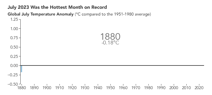
As the earth roasted last month, reaching a global average temperature that scientists have confirmed to be the highest on record for any month, the Colorado High Country got an uneven sampling of the heat.
While parts of the southwestern Colorado Rocky Mountains were locked under the same heat dome that broiled states like Arizona and New Mexico, the northern mountain region mostly escaped that unprecedented pattern of heat.
Still, most Coloradans, like people in many parts of the world last month, felt the influence of climate change helping to drive up temperatures. In the U.S., 244 million people — 73% of the population — experienced at least one July day with temperatures made at least three times more likely due to human-caused climate change, according to an estimate from independent scientists at the nonprofit Climate Central.
The record-breaking July was marked by heatwaves, “in multiple regions of the world,” a climate scientist told the United Nations this month. Based on data known as proxy records, which include cave deposits, calcifying organisms, coral and shells, the scientist said, it “has not been this warm for the past 120,000 years.”
The rising global frequency and intensity of extreme weather events, like the sustained and deadly heat wave in the southwest U.S., is consistent with well-established scientific understanding of the consequences of carbon pollution — mainly from burning coal, oil and natural gas.
According to the Copernicus Climate Change Service, at several points during July, global temperatures temporarily exceeded the 1.5 degree Celsius threshold above the 1850-1900 average — a warming limit set in the Paris Climate Agreement.
When global temperatures spike, some locales like the U.S. and Rocky Mountains, tend to be more sensitive to the overall climate change pattern than others areas, Climate Central director of attribution science Andrew Pershing said.
So, as the earth baked last month, Pershing said, the fingerprints of human-caused climate change were detectable in daily temperatures almost everywhere in the Colorado mountain communities at one point or another.
“We have these scary numbers — the hottest month ever probably in 100,000 years,” Pershing said. “It’s a little abstract. We don’t perceive that number, 1.5 degrees Celsius, at the global level. We don’t walk outside and feel that. You feel that through your local conditions.”
All sweaty on the Western Slope
The Spring Creek Fire near Parachute on the Western Slope burned through much of July 2023, as climate change intensifies the conditions that support wildfires.
Across much of Colorado’s Western Slope, July started out above average. Then it only got hotter, according to National Weather Service forecaster Brianna Bealo. The first triple-digit temperature day of the month in Grand Junction was July 11, Bealo said.
Then, all the way through July 31, the lowest daily high temperature recorded in Grand Junction was 98 degrees Fahrenheit, Bealo said. On July 17, Grand Junction Airport recorded a high of 107 degrees, tying the all-time high set in 2021 and smashing the previous record high for that day of 104 degrees set in 2010.
“The month itself started a few degrees above normal,” Bealo said. “But it definitely took off with a hurry.”
For most of July, a high-pressure system brought warm temperatures to the Western Slope that also kept conditions dry, Bealo said.
That same heat dome brought cities across the United States to a boiling point. On July 25, Phoenix, Arizona, recorded a temperature of 119 degrees, topping the daily air temperature record by three degrees, according to the National Aeronautics and Space Administration.
Phoenix recently endured at least 27 days with maximum temperature exceeding 110 degrees, and El Paso, Texas, suffered for 42 consecutive days at or above 100 degrees, NASA reported, adding that “extreme heat is the leading cause of weather-related death in the U.S.”
Right on the edge of that heat dome, the influence of climate change on Colorado’s Western Slope last month is irrefutable, Pershing said.
“In July, we really saw especially the southern third of the country, basically coast to coast, was unusually warm,” Pershing said. “And we were able to say there was a very strong climate fingerprint most days in that region.”
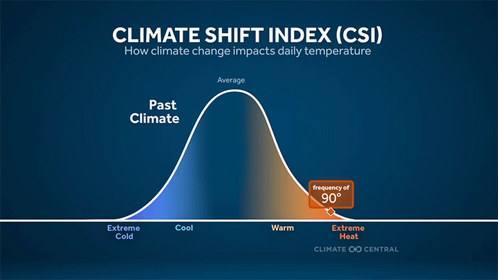
Climate Central’s daily attribution tool, the Climate Shift Index, applies the latest peer-reviewed methodology to map the influence of climate change on temperatures across the globe every day.
By comparing the existing climate to models of a world without human climate influence, the Climate Shift Index calculates how much more frequent extreme heat is on average now than it would have been in a world without greenhouse gas pollution, Pershing said.
On an overlay of the U.S. or world map, the tool outputs a level between 1 and 5 over geographic regions. Level 1 indicates very little human climate influence, while Level 3 is associated with a strong climate influence and means the hot conditions experienced in that region were made at least three times more likely due to climate change.
“Really what we’re trying to do is make this connection between the big climate change problem and what people are experiencing day to day through their weather,” Pershing said. “We’re not going to make a causal statement, but you can get close to that.”
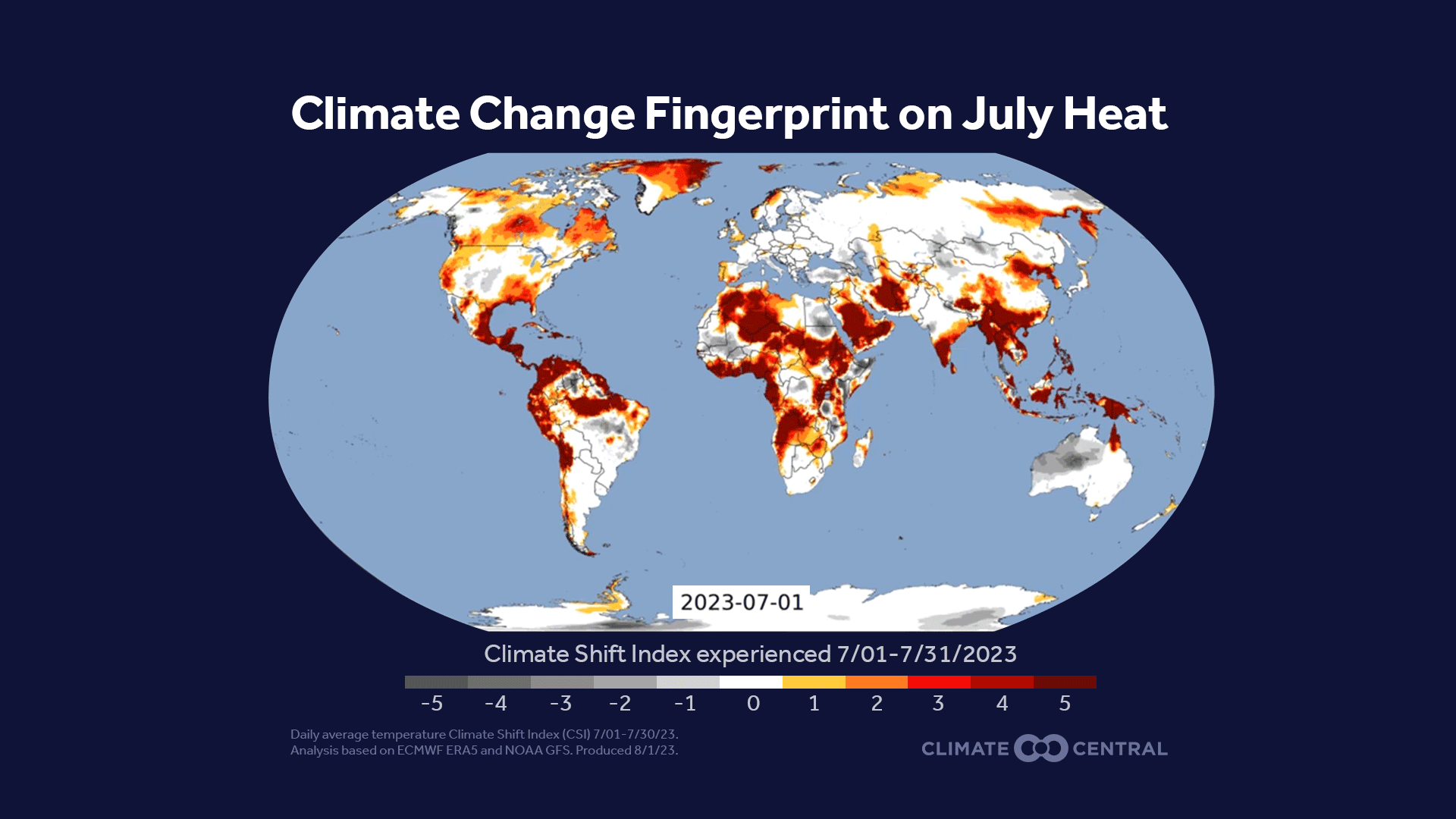
Nearly every day in July, the daily temperatures in the Grand Junction area showed a strong climate influence, several times maxing out the Climate Shift Index atLlevel 5. Level 5 events — conditions made at least five times as likely due to greenhouse gas pollution — would be very difficult, but not impossible, to encounter in a world without climate change.
Other parts of the Southwest under the same heat dome showed even stronger indicators of climate influences. Santa Fe and Albuquerque, in New Mexico, and Mesa, Arizona, averaged a Level 4 or higher on the Climate Shift Index throughout July, according to Climate Central.
Pershing said remove climate change from the equation and it’s hard to imagine a summer like what most of the southwest experienced.
“Thats been kind of the remarkable thing about the event in the Southwest,” he said. “It’s just been day, after day, after day, after day — the persistence of that event is even more remarkable to me than the extremes.”
Carleigh Bernard and Clayton Faber, who had driven to Summit County for a concert at the Dillon Amphitheater, were more than happy to encounter temperatures almost 20 degrees cooler in the mountains on Tuesday, July 25, 2023.
The red badge of Colorado
Even as Colorado’s Front Range and central mountain regions escaped the heat dome that hung over the southwestern part of the state for most of July, the fingerprints of climate change became visible as temperatures climbed later into the month.
On average, July temperatures were just below normal in Denver, right around average in Boulder and about a degree above normal in Dillon, according to National Weather Service forecaster Russell Danielson.
“Generally speaking the plains were about a degree below normal and the mountains were about normal to a degree above normal,” Danielson said.
The Front Range and central mountains tapped more into the cool weather witnessed in Denver, with most areas getting average to above-average precipitation, Danielson said. After starting off cool — if not downright chilly some places in the mountains — July got increasingly warm in the central mountains, and the signal of climate change began to emerge.
In Dillon on July 1, there was a high of 66 and a low of 29, making for a cold start to the month, Danielson said, but by July 25 temperatures had warmed up considerably, with a high of 84 degrees record that day.
This echoed weather patterns in Denver, where the high on July 5 was only 71 degrees, 11 degrees below normal, Danielson said. But, by the end of the month Denver International Airport hit 97 degrees on July 23, 98 degrees the next two days and remained above 90 through the rest of the month, he said.
Two girls talk and enjoy a sweet treat at the Wagner Park playground on Tuesday, July 25, 2023, in downtown Aspen. The Roaring Fork Valley broke heat records during a heatwave earlier in the month.
Through the last week of July, Denver, the Front Range and the central mountains region reached level 4, or “extreme” on the Climate Shift Index at least once, meaning climate change made the balmy conditions at least 4 times more likely to occur.
“The main thing is that Colorado has been at this edge in July,” Pershing said. “Where you are in the state, which day, determines whether you’ve been tuning into the plains pattern or the southwest pattern.”
While Colorado’s central mountains were not locked into the same heat dome pattern that gripped the southwest in July, at the start of August, Hurricane Hilary helped shift the high pressure system east, trapping almost the entire state beneath it.
“When I look at the maps from our Climate Shift Index, Colorado is just really glowing bright red, Level 5,” Pershing said. “Those daily temperatures are five times more likely, or more, because of climate change. These are the conditions that you should expect to see more and more frequently as the years progress.”
Fahrenheit 2023
Until humans curb carbon emissions, global temperatures are only projected to increase. According to the National Oceanic and Atmospheric Administration, there is a 99% chance of 2023 ranking among the top five hottest years on record.
Regardless of how 2023 ultimately ranks, the World Meteorological Organization estimates that there’s a 98% chance of at least one year between 2023 and 2027 exceeding the current warmest year on record.
Coloradoans should expect more months like July in the years to come, Pershing said.
“The U.S. is a big country, but we’re only a small part of the planet,” Pershing said. “There were a lot of other places in July that were experiencing really unusual heat: southern Europe, Spain, Greece, the Middle East, the Persian Gulf region, Iran, China.”
That’s the true story of July, Pershing said. Not only was it hot in Colorado, but it was hot throughout the world — and it will only continue to get hotter if humans don’t take action to curb greenhouse gas emissions, he added.
“If it were just one of these places around the world, you might say natural variability,” he said. “The fact that this is happening all over the world is just a really clear signal we’re dealing with a climate that has been altered by humans.”
Extreme heat can be a major stressor on human populations, Pershing noted, calling the July temperatures a “buckle up” moment for society. Already, CNN has reported that at least 147 people in just five U.S. counties have died this summer from extreme heat, “a mere snapshot of the fatal toll.”
“Heat is just this pressure that gets pushed onto society,” Pershing said. “You see places that are stressed. Those are places that start to break. People who are unhoused, dealing with addiction, poor, working outside, those are the people you really see impacted by these events.”
Just because some mountain towns in the Colorado Rocky Mountains have the benefit of elevation to help keep people cool, climate change could still have significant impacts on local ecosystems and economies, Pershing said.
In many places in the U.S., winters are warming faster than summers, applying pressure to the winter sports industries that crave cold temperatures, Pershing said. Especially in the High Country, where plants and animals have evolved to survive through long, treacherous winters, that warming will also have a significant impact on the environment.
“That’s probably the thing that is the most at risk when you’re talking about the Rockies, this beautiful natural area,” Pershing said. “The environment that the animals and plants are encountering is very different from what they evolved to be able to handle.”
Limiting warming to 1.5 degrees or 2 degrees Celcius will require global emissions to peak by 2025 at the latest — and “deep, rapid and sustained emissions reductions” throughout 2030-2050, according to the Intergovernmental Panel on Climate Change.
That will take a collective and concerted effort to achieve, Pershing said, but people across the political spectrum are coming to recognize the threat that climate change poses.
In Colorado, legislators last year passed a law pledging to reduce overall greenhouse gas emissions by 26% below 2005 levels by 2025, 50% by 2030, and 90% by 2050. There are currently 22 states with 100% clean energy goals, according to the Clean Energy States Alliance.
“I think the most important climate solution individuals can take part in is to talk about it,” Pershing said. “Talk about it with your friends, with your neighbors. This is a part of the world we can’t get away from. We have to be able to talk about it the same way we talk about other challenges and stresses in our life.”
Colorado’s Rocky Mountains are almost guaranteed to see an El Niño winter. Here’s what that could mean for ski season.
It may be August, but early indicators are already brewing for what the 2023-24 winter season could look like in Colorado.
At Breckenridge Ski Resort, a dusting of white on Peak 6 was photographed on Aug. 11. Whether it will herald another blockbuster ski season remains to be seen, though one factor is nearly certain: atmospheric patterns are set to change this winter.
“We are going into what looks to be a strong El Niño season,” said National Weather Service meteorologist Bernie Meier.
El Niño patterns can form when surface temperatures in the equatorial Pacific Ocean (off the coast of South America) rise above average by 0.9 degrees Fahrenheit for three consecutive months, according to Meier.
El Niño pushes the jet stream south and can bring more precipitation and cooler temperatures to southern regions. In Colorado, this can translate to heavier, wetter snow in the southwest, particularly for the San Juan Mountains, as well as the central mountains. In the state’s northern areas, such as Steamboat Springs, weather may be warmer while snow is dryer, Meier said.
“Not every year is a great snow producer, but if you look at the history, we tend to do better than not for snowfall with El Niño,” Meier said of the southern and central mountain region.
The prediction comes after the past three winters saw a La Niña pattern (the inverse of El Niño), according to an Aug. 14 report by meteorologist Alan Smith on OpenSnow.
La Niña occurs when the same ocean temperatures fall below average and is defined by wet, cold weather in the north and dryer, warmer weather in the south. According to Smith, the succession of La Niña patterns over the past three years has only happened three times since 1950 — a “rare occurrence.”
“Confidence is increasing that we could see a strong El Niño this year,” Smith wrote in his report, adding the last strong El Niño pattern was in 2015-16.
However, neither pattern guarantees an outcome for winter conditions, especially at the local level.
“It’s one of the few things that we have any shred of ability to forecast six months in advance,” said OpenSnow founder Joel Gratz. “Just because there’s a correlation, it doesn’t mean that every year is guaranteed to be that way.”
Last winter’s La Niña pattern should have been characterized by heavy snowfall in the north and less in the south, but that wasn’t completely the case in Colorado.
“It kind of broke the rule of what you’d expect last year,” Meier said of the La Niña pattern.
By late last winter, however, the La Niña pattern had begun to phase out, with ocean temperatures beginning to rise in March, Meier said.
“We’ve almost met the conditions for El Niño already and should carry on into winter and next spring,” he added.
Though a stronger La Niña or El Niño pattern can mean average or above-average snowfall, in some areas there isn’t a strong correlation between snow and atmospheric patterns, such as around Colorado’s Continental Divide.
And a 90-day forecast from NOAA shows equal chances for above, below or normal temperature and precipitation, making it anyone’s guess for how the beginning of ski season will kick-off in the Colorado High Country.
“I’m curious to see how this is going to play out,” Meieir said.
Colorado High Country forecast is ‘hot and dry’ as Hurricane Hilary prepares to disrupt the monsoon-pattern storms
A hot and dry spell will likely descend on the Colorado Rocky Mountains this weekend as Hurricane Hilary barrels toward California, according to National Weather Service forecasters.
Hurricane Hilary’s unusual path toward southern California is caused in part by a giant heat dome hanging over the middle of the country. That heat dome, created by a high-pressure system, is expected to bring warmer temperatures throughout Colorado this weekend, said Russell Danielson, a forecaster for the National Weather Service’s Boulder office.
“There is a very, very strong, almost record-breakingly strong, ridge of high pressure over the central United States and winds travel cyclonically around it,” Danielson said.
That ridge of high pressure is drawing Hurricane Hilary around it, up the Pacific, into California and toward Canada, Danielson said. The storm is is expected to have significant impacts on the Southwest, and as it travels around the high-pressure system, Colorado will be warmer and drier than usual, he said.
“It steers the hurricane and the remnants of the hurricane around us. So we mainly stay hot and dry,” Danielson said. “(Hurricane Hilary) won’t impact us at all here in Colorado. It will be steered around, and we’re just under this high-pressure system.”
The heat will likely be accompanied by a slight chance of thunderstorms in the mountains most days, Danielson said, but with less precipitation than recent weeks when monsoonal patterns were strong.
With plenty of precipitation, the monsoonal pattern has kept wildfire danger at bay in northern Colorado so far in August. Red, White & Blue Fire Protection District Captain Matt Benedict announced Friday that the county’s fire danger would remain moderate for the time being.
A stand-up paddleboard rests on the edge of an island near Giberson Bay on Dillon Reservoir as the sun reflects off its surface on Friday, July 21, 2023. A hurricane in the Pacific Ocean is expected to disrupt the monsoonal pattern that’s been active in Colorado, pulling moisture away from the state.
The high pressure system may break down a little bit into Tuesday and Wednesday, bringing the possibility of higher precipitation, Danielson said, but by the following weekend it could build back up.
Meanwhile, the monsoonal pattern is also expected to drop off in the mountains of southwestern Colorado, which is still experiencing moderate to low drought conditions after a hot and dry July.
Friday, Aug. 18, marked “the big day” for moisture in southwestern Colorado for the near future, said Grand Junction office National Weather Service forecaster Brianna Bealo, as Hurricane Hilary is expected to pull drier air into the area through the weekend.
“Unfortunately, with the track that Hilary is forecasted to take, it is actually going to pull some drier air into western Colorado through the weekend,” Bealo said. “Once Hilary gets out of the picture, we do return to that more typical monsoonal pattern into mid-next week.”
Thunderstorms may persist in the mountains, Bealo said, but they will be more scattered and drop less precipitation than in recent days. Wetter weather may begin to return Tuesday and stick around into mid- to late-next week, she said.
“We’re going to see a little bit of a drying trend for the weekend. The temps might be a little warmer, we might not see as much heavy rain as we’ve seen,” Bealo said. “But cooler temperatures and that rain will return next week.”